Hinweis: Das ist ein alter - nicht mehr gewarteter - Artikel des AEIOU. Im Austria-Forum finden Sie eine aktuelle Version dieses Artikels im neuen AEIOU.
Oberösterreich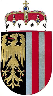
© Copyright Coat of arms of Upper Austria Upper Austria (Oberösterreich): area 11,979.72 km2; pop. 1,333,480 (1991); population density: 111 per km2; capital: Linz; dwellings: 307,850; households: 483,233; 3 towns vested in charters, 15 administrative districts, 43 court districts, 445 municipalities (of which 25 are towns and 132 market towns), Higher Regional Court and district court in Linz, district courts in Ried, Steyr and Wels. Geographic Location: Upper Austria extends from the Böhmerwald Mountains to the Dachstein Massif mountain and from the River Inn to the River Enns; bordered to the east by Lower Austria, to the south by Styria, to the south-west by the province of Salzburg, to the west by Germany (Bavaria), to the North by Czech Republic; literal name "Österreich ob der Enns" (the part of Austria beyond or west of the River Enns) until the 19th century. Geographic Features: Upper Austria is divided into the Hausruckviertel, Traunviertel, Mühlviertel and Innviertel regions ("Viertel"- meaning "quarter"). The Mühlviertel region in the north, part of the Bohemian Massif (Austrian Granite Plateau), extends to the southern shore of the River Danube with the elevated ridges of Sauwald and Kürnberger Wald Mountain. The region around the River Danube subdivides into the Passauer Engtal valley, 3 basins (Eferding, Linz, Machland) and Strudengau valley. The Alpenvorland south of the River Danube encompasses the Innviertel region, the Hausruckviertel region with Hausruck mountains and Kobernaußerwald hills, the Traunviertel region (Attergau and Traungau) and the Traun-Enns plain followed to the south by the Salzkammergut District region and the Upper Austrian Eisenwurzen region; in the south the narrow sandstone belt borders on the broad, wide formations of the Northern Limestone Alps with Schafberg mountain, the Höllengebirge Mountains, Traunstein Mountain, Kremsmauer Mountain and the Sengsengebirge Mountains along the southern border of the province, followed by the karstic Dead Mountains (Totes Gebirge), Warscheneck mountain (alt. 2,387m), Pyhrgas mountain (alt. 2,244m) and Dachstein mountain (alt. 2,995m). South of the River Danube Upper Austria is drained by three main tributaries of the River Danube: the River Inn (with the rivers Salzach, Mattig, Ach, Antiesen and Pram), the River Traun (with the rivers Ager, Alm and Krems) and the River Enns (with the River Steyr) - north of the River Danube by the Rivers Kleine Mühl and Große Mühl, the rivers Rodl, Gusen, Aist and Naarn (also tributaries of the River Danube). The Salzkammergut region is renowned for its numerous lakes, including Lake Attersee, Lake Traunsee, Lake Wolfgangsee, Lake Mondsee, Lake Hallstatt and Lake Irrsee; among the smaller ones Lake Gleinkersee, the Ödsee Lakes, Lake Almsee, Lake Offensee, Lake Laudachsee, the Gosauseen Lakes, Lake Nussensee, Lake Schwarzensee, the Langbathsee Lakes and marsh ponds in the Upper Innviertel region (Ibmer Moos). The climate of Upper Austria is characterised by a general eastward movement of air with copious precipitation in the alpine border region (over 2,000 mm yearly average rainfall in the Salzkammergut region) and foehn in the alpine valleys. In the Alpine Forelands the prevalence of westerly weather systems causes a changeable climate. The climate of the granite and gneiss high plains of the Mühlviertel region is somewhat rougher (cold winters) than that of the Alpine Forelands. Population: The majority of the population is Roman Catholic (82.6 % in 1991); the population density of 111 inhabitants per km2 is significantly above Austrian average (93 inhabitants per km2). 17.1 % of the entire Austrian population live in Upper Austria, thus making it the third most populous Austrian province after Vienna (19.8 %) and Lower Austria (18.9 %). Between 1981 and 1991 Upper Austria experienced a 5 % population increase (fourth-highest population increase of all provinces), of which 60 % was accounted for by an excess of births over deaths (38,900 more births than deaths), and 40 % by immigration (migration balance surplus of 25,100 persons compared to the remaining provinces and migrants' countries of origin). The population is mainly concentrated in the area of Linz. With a population of 203,044 (15.2 % of the entire population of Upper Austria) Linz is the third-largest municipality of Austria after Vienna and Graz. About one third of the entire Upper Austrian population lives in Linz and its metropolitan area. - Within the territorial organization of the Roman Catholic church, Upper Austria constitutes the diocese of Linz. Local customs include the Glöcklerlauf in Ebensee and Gmunden (winter festival at Epiphany; people dressed up in huge heads decorated with various motifs and bells Glocken" symbolically chase away the evil spirits of winter and ask for the blessing of good spirits), the Leonhardiritt in Pettenbach (horse-back ride on the first Sunday in November with a procession) and lake processions at Corpus Christi in Traunkirchen and in Hallstatt. Fairs and carnival celebrations are popular folk festivals following old traditions. The custom of wearing Upper Austrian traditional costumes ("Tracht") is passed on from generation to generation, especially in the Salzkammergut district (Dirndl and embroidered leather satchels), the Goldhaube being a unique type of traditional head dress. Common Farmhouse Types include the Vierkanter (quadrilateral type of farmstead) in the Traunviertel region, in central Upper Austria between Wels, Linz, Enns, Steyr and in the Machland region, the Vierseithof (quadrilateral type of farmstead) in the Innviertel region and the Mühlviertel region, Dreiseithof and Dreikanthof (trilateral types of farmhouses) in the Mühlviertel region and the alpine Einhof (type of solitary farmhouse) on the northern fringe of the Alps; the Haufenhof (type of farm house with "scattered" buildings) is common in the Upper Austrian Eisenwurzen region, and especially in the area extending from the Almtal valley over the Windischgarsten basin to the Enns Valley and around the Lower Austrian border, today often in the form of extensions to Mehrseithof (types of farm houses in polygonal shapes). Smokehouses have been preserved in the Mondsee region between Lake Mondsee and Thalgau. Agriculture: Agricultural production has experienced a significant increase although the number of those employed in the field of agriculture and forestry has declined by 33,500 since 1971 (in 1971 18 %, in 1991 only 9.3 % of the workforce in the field of agriculture and forestry). The volume of harvested wheat doubled between 1960 and 1990 and has declined only slightly over the past years (90 % in 1996), the yield of sugar beet has increased by 53 % since 1960, dairy production by 18 %. 97.5 % of all agricultural businesses are small and medium-sized farms (up to 50 hectares). Ideal conditions for growing grain are mainly found on the plains of the Innviertel region and the Traun-Enns plateau; other crops include corn, alternative cultures and fodder plants; the tradition of fruit-growing for the production of must is another important economic activity. Upper Austrian livestock farmers own the largest stock of cattle and pigs in Austria. Large resources of wood in the Hausruck mountains, the Kobernaußerwald hills, the Weilhartforst forest, the Mühlviertel region and in the alpine regions make forestry a significant economic factor. Economy: A typical farming region only 50 years ago, Upper Austria is today one of the most important industrial regions of Austria, while the proportion of agricultural production remains significant. Industrialisation took place between 1938 and 1958. Since the mid-1950s the Upper Austrian economy has been experiencing above-average growth. Economic structures are marked by high labour productivity, strong focus on raw materials and capital goods, large production units and emphasis on the export of goods. The number of businesses rose by 13.5 % from 1981-1991 (excluding agriculture and forestry), the number of gainfully employed persons increased by 13.6 %; the highest increase in the number of businesses was registered in the districts in the area around Linz (34.9 %), the city of Wels (29.5 %) and the city of Linz (20.4 %). The growing disparity between city centres and the periphery is a result of the declining level of employment in the agricultural sector and increased mobility in the workforce. Located along the fringe of the Mühlviertel region, in the northern Innviertel region and in the southern part of the districts Kirchdorf an der Krems and the area around Steyr are areas with less favourable economic structures and very few job opportunities (high proportion of agricultural production and high proportion of sunset industries like mining, raw materials and the textile industry). Upper Austria has the largest share of Austrian businesses in the industrial sector (760 businesses with more than 20 employees at the end of 1996) and the highest number of those employed in the industrial sector (around 114,000); more than one third work in the metropolitan area and in the area around Linz. More than half of the Upper Austrian businesses in the industrial sector with approximately 70 % of all employees and 70% of total Upper Austrian net production value are concentrated in the agglomerations of Linz and Wels, as well as in Gmunden and Vöcklabruck. More than half of the businesses established in the industrial sector between 1973 and 1993 are located in these districts. Further important production sites, partially dominated by sole proprietorships, are the towns of Braunau am Inn, Ried im Innkreis, Steyr, Laakirchen and Lenzing. Various important Austrian industries are centred in Upper Austria: 61.2 % of the production of iron, 33.3 % of the vehicle industry, 32.3 % of the manufacturing and steel industry, 29.0 % of the foundry industry (based on the number of employed persons in December 1995). Large-scale enterprises dominate the iron and metal industry, the manufacturing and steel industry, the vehicle and high technology industry as well as the chemical and pharmaceutical industry, whose main production site is Linz, with its main companies including VOEST-ALPINE Stahl AG, VOEST-Alpine Technologie AG and the OMV-Chemie-Gruppe corporation. Steyr is an important centre for the production of motor vehicles, engines, ball bearings and hunting weapons; cellulose and synthetic fabrics are produced in Lenzing. Further industries include Austria's largest aluminium plant in Ranshofen, and long-established iron and metal processing plants in the Eisenwurzen region (Molln, Roßleithen, Kirchdorf an der Krems and Micheldorf in Oberösterreich). Further important sectors are the food industries, tobacco and coffee industries (tobacco plant in Linz), paper-producing and paper-processing industries (paper mills in Steyrermühl, Laakirchen and Nettingsdorf-Ansfelden), wood-processing industries and cement production in Gmunden and Kirchdorf an der Krems, and the production of asbestos cement in Vöcklabruck. The importance of textile and clothes manufacturing industries such as the traditional linen weaving mills and textile production in the Mühlviertel region has been on the decline over the past decades. Upper Austrian industries hold a leading role in the technology sector, and in the water and energy supply sector. - Mining of salt (salt) in Hallstatt and Bad Ischl, the recovery of crude oil and natural gas in the Alpine Forelands and the storage facilities for natural gas at the oil fields of Thann and Puchkirchen; the extraction of gypsum near Spital am Pyhrn and the extraction of kaolin in Kriechbaum-Weinzierl are further important economic factors. Other natural resources: limestone in the Limestone Alps, quartz sand for glass production along the southern fringe of the Mühlviertel region, loams and common clays for brick production; granite is extracted in the Innviertel region (Schärding area) and the Mühlviertel region (Perg/Mauthausen area), gravel sand in the districts of Wels and Gmunden. Extraction sites of brown coal in the Hausruckviertel region and along the River Salzach have been closed. - Upper Austria is the largest producer of electric energy of all Austrian provinces, with an annual output of approximately 13.7 billion kWh (hydroelectric power plants along the Rivers Danube, Inn, Mühl and Enns and thermoelectric plants of electric power suppliers and industries). Tourism: The significance of tourism is also increasing, from 5.6 million overnight stays in 1962 to 8.2 million in 1992, but with a drop back to 6.6 million in 1997. Tourist resorts are located around the lakes and in the mountains of the Salzkammergut and Traunviertel regions. Bad Ischl, Bad Schallerbach, Bad Hall, Gallspach, Bad Goisern and others are important mineral spas and health resorts. Public fairs in Wels and Ried have developed into international agricultural fairs. Traffic: Upper Austria serves as an international traffic junction with an extensive, strongly frequented railway system (railway junctions in Linz, Wels and Attnang-Puchheim) and important European road and motorways including the Westautobahn A 1, Innkreisautobahn A 8, Pyhrnautobahn A 9, Mühlkreisautobahn A 7 and Linzer Autobahn A 25. Important long-distance traffic routes such as the E 5 (Budapest- Vienna- Nuremberg- Cologne) and the E 14 (Stettin- Prague- Salzburg- Villach - formerly the road linking Prague- Linz- Trieste) intersect in Linz. The Danube river port with its associated free trade zone is Austria's most important trans-shipment centre for freight traffic (total trans-shipment turnover of 4.439,680 t in 1997, approximately 61 % of total volume of trans-shipment on Austrian waterways). The River Danube's status as a transportation route was enhanced by the completion of the Rhine-Main-Danube canal; there is also passenger shipping on the River Danube and on larger Upper Austrian lakes. The airport of Linz-Hörsching has an important function as overspill airport for flights arriving at Vienna International Airport (VIA). Culture and the Arts: Upper Austria has numerous sites with archaeological finds of prehistoric cultures which are named after Upper Austrian lakes Salt Mondsee Culture, Attersee Culture and Hallstatt Culture); and finds dating back to Roman times (Lauriacum/Lorch, Lentia/Linz, Ovilava/Wels). Significant works of Christian art and architecture from the early Christian Middle Ages include the Tassilo chalice and the Codex Millenarius in Kremsmünster abbey as well as St. Martin's church in Linz. Parts of the collegiate churches in Wilhering, Baumgartenberg, Lambach, Kremsmünster and Schlägl and the charnel house in Mauthausen are in Romanesque style. Representative of the Gothic style are the parish churches in Enns, Steyr, Braunau am Inn, Eferding and Mondsee, Schaunberg Castle, Prandegg Castle and Ruttenstein, and the burghers' houses in Steyr, Freistadt, Enns and Wels. Winged altars in St. Wolfgang im Salzkammergut, Kefermarkt, Hallstatt, Waldburg, Rauchenödt, Gampern and Gebertsham, the Altdorfer paintings in St. Florian abbey as well as frescoes in St. Leonhard bei Pucking also date back to the Gothic period. The following works of architecture from the Renaissance period have been preserved: burghers' houses in Steyr, Wels and Linz, the Stadtturm tower in Enns, Aistersheim Palace, Würting Palace, Weinberg Palace, Greinburg Palace and Hartheim Palace and the Landhaus in Linz. Upper Austrian churches and secular buildings in Baroque and Rococo style: in Reichersberg, Waldhausen, Schlierbach, Garsten, Gleink, Ranshofen, Suben, St. Florian, Kremsmünster, Spital am Pyhrn, Engelhartszell, Wilhering, Stadl-Paura, Christkindl, Linz and Steyr. Aurolzmünster, Hohenbrunn (St. Florian) Zell an der Pram and Neuwartenburg are renowned for their Baroque palaces. The Schwanthaler family and M. Guggenbichler are famous Upper Austrian artists of the Baroque. Buildings in Empire and Biedermeier style are found in Bad Ischl and Ebensee. During the 2nd half of the 19th century Upper Austria was a centre of art, the beginning of the 20th century was the epoch of architects such as M. Balzarek, J. Schulte and the artist L. Forstner as representatives of Judgendstil (Art Nouveau) and New Objectivity. Many church buildings all over Upper Austria as well as apartment buildings, cultural institutions, administrative buildings and school buildings (especially in Linz) are works of modern architecture. Numerous Gmunden Keramik ceramic products of artistic value, the Viechtau woodcarvings exhibit folkloric character. Peasant furniture of often outstanding quality, marked by different regional characteristics, is another trademark of Upper Austria. - Renowned Upper Austrian poets and authors include Dietmar von Aist, Wernher der Gartenaere, authors from the Baroque epoch such as J. Beer, S. Rettenbacher, M. Lindemayr and J. Denis, later A. Stifter, H. Bahr, E. Handel-Mazzetti, R. Billinger and J. Zerzer and contemporary writers such as M. Haushofer, H. Eisenreich, R. Bayr, K. Klinger, G. Fussenegger, F. Rieger, A. Brandstetter, F. C. Zauner and W. A. Mitgutsch; Upper Austria was the chosen home of T. Bernhard. F. Stelzhamer, K. A. Kaltenbrunner, N. Hanrieder and N. Purschka, who are famous for their vernacular poetry. The province's greatest composer is A. Bruckner; Upper Austria is also the home of W. Kienzl, J. N. David, the brothers J. and H. Kronsteiner, H. Eder, F. Dallinger and B. Sulzer and of the conductors T. Guschlbauer and F. Welser-Möst. The Bruckner conservatory in Linz, the extensive network of music schools and especially the Brucknerhaus in Linz, which was opened in 1974 (centre of the annual Bruckner festival and the international Ars Electronica Festival) are of special significance for the province's musical life. The graphic artist A. Kubin, whose chosen home was Zwickledt, is a renowned representative of fine arts in Upper Austria. J. B. Reiter, A. Obermüllner, A. Greil, J. B. Wengler, K. Kronberger, A. Wach, M. Bilger-Biljan, V. Eckl, A. Lutz, F. Fröhlich, L. Roppolt, R. Hoflehner, O. Zechyr, C. L. Attersee, S. Anzinger and G. Damisch are further famous Upper Austrian painters, renowned sculptors include L. Kasper, H. Bayer, F. Forster, M. Stockenhuber, H. Gsöllpointner, E. Reiter and W. Viehböck. The area of object art and media art is mainly represented by W. Cooper and V. Export. Famous Upper Austrians renowned for their achievements as members of the Vienna School of Medicine include J. Wagner-Jauregg (Nobel prize), A. Eiselsberg, H. Finsterer, W. Denk, A. Werkgartner and K. Fellinger. Monasteries and convents were the first centres of learning and culture, later the Estate schools for the sons of nobles (ständische Landschaftsschule) played a significant role in the cultivation of liberal arts, since the 19th century this task has traditionally been the responsibility of the Upper Austrian Provincial Museum (extension of facilities to include Linz Castle in 1959-1966 in order to exhibit the cultural history collection) and the Upper Austrian Regional Archives; after World War II the Adalbert-Stifter-Institut des Landes Oberösterreich, the Institute for Adult Education and Regional Studies (today Institute of Popular Culture), the Johannes Kepler University (since 1966), the School of Art and Industrial Design in Linz (1973) and the University of Catholic Theology (pontifical faculty since 1978) also play an important role in Upper Austrian cultural life. Numerous museums and permanent local history exhibits (e.g. Innviertler Volkskundehaus in Ried im Innkreis, Museum Lauriacum in Enns, Heimathaus Freistadt, the Museum of Work in Industry in Steyr, Stadtmuseum Bad Ischl, Heimathaus Mondsee) are further cultural attractions. The Landestheater in Linz was reconstructed during the 1950s and stages performances on 3 stages. History: Settlement in the area began in the Palaeolithic Age and with the Neolithic settlements near Lake Mondsee. Recorded testimonies of early civilizations mainly date back to the Hallstatt era of the early Iron Age. The area south of the River Danube was part of the province Noricum during Roman times (Ovilava/Wels became the capital of riparian Noricum). During the 6th and 7th centuries Bavarian settlers and Slavic settlers in the east and southeast began intermixing with the Roman-Celtic population. In 788 the Bavarian tribal duchy of the Agilolfing dynasty, its the eastern part between the River Inn and the River Enns, became a province of the Frankish-Carolingian empire of Charlemagne. Charlemagne incorporated the Traungau region into the newly structured domains in the east along the River Danube around 800 A.D. After the victory of the Magyars over the Bavarians at Bratislava in 907, the River Enns once again became the eastern border of the Bavarian duchy; during the 10th and 11th centuries, the duchy's eastern part was ruled by the counts of Lambach (who were also margraves in the area of the River Mur/Mura from 1035 onwards); in the middle of the 11th century the land passed into the dominion of the Chiemgau-based Otakars, who later became margraves of Styria. During the 2nd half of the 12th century the dukes of Babenberg succeeded in gaining considerable influence west of the River Enns at the expense of the Bavarian dukes. The Babenberg domains already included the Machland area north of the River Danube since the 10th and the 11th centuries and the Mark (meaning both "province" and "border") of Ried extending to the Haselgraben area north of Linz since around 1100. In 1192, the Babenberg dynasty inherited the duchy of Styria from the Otakars (Georgenberg Treatise, 1186); they intensified their policy of acquisition west of the River Enns (after 1200, Linz and Wels) and in the Mühlviertel region. The formerly Otakarian nobility in the Upper Austrian area declared their allegiance to Styria and did not join Austrian nobility and until 1236; Austria; the Pyhrn range became the southern border against Styria. First documented mention of "upper Austria" (Austria superior), a territory that covered the area between the River Ybbs and the Hausruck Mountains, dates back to the mid-13th century in the form of independent noble estates with administrative and executive powers ("adelige Gerichts- und Landesgemeinde"). The lord justice (Landrichter) of Upper Austria, Konrad von Sumerau (documented mention in 1264), is considered the first Landeshauptmann (Provincial Governor) of Upper Austria. In 1281 King Albrecht I of the Habsburg dynasty created a court and administrative district "ob der Enns" (over or beyond the River Enns), which was governed by a "Landrichter ob der Enns" (lord justice and prefect) and thus became the core area of the land "ob der Enns". In the course of the 13th century, similar units governed by common law developed in the Machland region, in the Mark of Ried, in the counties of Waxenberg and Schaunberg, in the domains of Steyr and Ischlland (Salzkammergut region), which in the course of the 14th and 15th centuries were integrated into the gradually growing land "ob der Enns" by princes of the Habsburg dynasty and by governors from the dynasty of the squires of Wallsee. Upper Austria received its own coat of arms around 1390 under Duke Albrecht III after the victory of the Habsburg forces over the powerful counts of Schaunberg (the so-called Schaunberg feud), which has remained the coat of arms of the province of Upper Austria to this day. In 1478 Upper Austria was divided into four regions (Hausruckviertel, Traunviertel, Mühlviertel and Machland), complying with the wish of the Estates and the office of chief justice and prefect "ob der Enns" became the office of Landeshauptmann (Provincial Governor). From the beginning of the 15th century the land "ob der Enns" became increasingly independent of the Archduchy of Austria ("under the River Enns"). From 1458 to 1463 Archduke Albrecht VI ruled an independent "Duchy of Austria ob der Enns", first documented mention of Linz as its capital in 1490. Subsequently, the territory of Upper Austria continued to legally remain part of the Archduchy of Austria until modern times, although its status remained controversial. - In 1506, emperor Maximilian I won the Mühlviertel domain Rannariedl and, among others, the Bavarian Mondsee and St. Wolfgang lands, which remained in pledge to the Archbishop of Salzburg until 1565. The prince-bishops of Passau had extended their domains in the northernmost part of the Mühlviertel region since the 12th century. In the course of the 16th century they had to acknowledge Austrian sovereignty over an area which, since 1289, gradually extended westward from the River Große Mühl to the River Ranna. The border between the prince bishopric of Passau and Austria, that is the land "ob der Enns" north of the River Danube (equivalent to the contemporary Austrian-Bavarian border) was fixed by contract in 1765. During the time of the Reformation and the Counter-Reformation Upper Austria was shaken by the violent fights of the peasants' uprisings, directed mainly against Bavarian foreign rule and religious oppression. In 1779 empress Maria Theresia was awarded the Innviertel region from Bavaria in the Peace of Teschen (Děčín); the entire area "ob der Enns" north of the River Danube was united under the name of Mühlviertel. In 1782 the domains of Obernberg am Inn and Vichtenstein an der Donau, which up to that time had been under the rule of Passau, were also integrated into the "Land ob der Enns". In 1785 Emperor Joseph II founded a bishopric coextensive with Upper Austria under the name of Linz. In 1803 Austria had to cede the county of Neuburg am Inn to Bavaria. This county had been under Austrian rule since the 13th century although its status had always been controversial. Also ceded to Bavaria were the Innviertel region and the western part of the Hausruckviertel region during the time of the Napoleonic Wars from 1809 to 1816. Conversely, the duchy of Salzburg was incorporated into "the Land ob der Enns" as the fifth region from 1816 to 1849 and in 1860/1861. In 1861 the uncertain constitutional status of Upper Austria was finally settled and established as "Austrian Archduchy ob der Enns" with an elected Landtag as opposed to (Lower) Austria and granted equal rights. After the fall of the Austro-Hungarian monarchy in 1918 the new province was officially named "Upper Austria", its unofficial name since the 17th century. From 1938 to 1945 Upper Austria, together with the rest of Austria, was part of the German Reich, Upper Austria constituted the "Reichsgau Oberdonau" to which the bordering areas of southern Bohemia and the Styrian Auseer Land region also belonged (until 1948). During the occupation by the Allied forces from 1945 to 1955 the part of Upper Austria south of the River Danube was under American administration, the Mühlviertel region (and the area around Gaflenz im Ennstal) were part of the Soviet zone. In 1958 Upper Austria was awarded the municipality Münichholz by Lower Austria, which became part of the town of Steyr. The Upper Austrian provincial constitution in force is enshrined in Upper Austrian Provincial Constitutional Law (Landesverfassungsgesetz 1991, Landesgesetzblatt No. 122, Landesgesetzblatt version 17/1998). The Upper Austrian Landtag (provincial diet) comprises 56 members. Since 1945 the Landeshauptmann (provincial governor) has been a member of the ÖVP; for the legislation period 1997-2003 the provincial government consists of 4 ÖVP members, 3 from the SPÖ and 2 from the FPÖ. Upper Austria holds 32 seats in the Nationalrat and 11 in the Bundesrat. 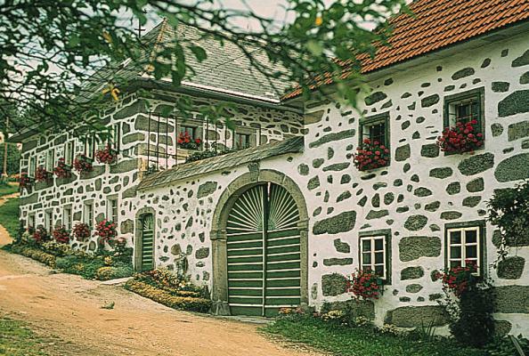
© Copyright Upper Austria: farmstead in the Mühlviertel region 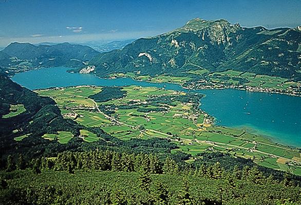
© Copyright Upper Austria: view at Lake Wolfgangsee with the village of St. Wolfgang and Schafberg mountain. 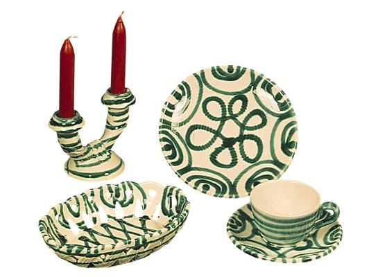
© Copyright Upper Austria: Gmundner Keramik ceramic products 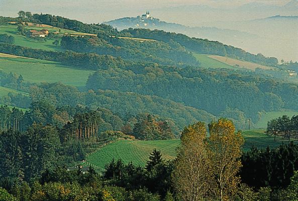
© Copyright Upper Austria: the Mühlviertel region at Gallneukirchen. 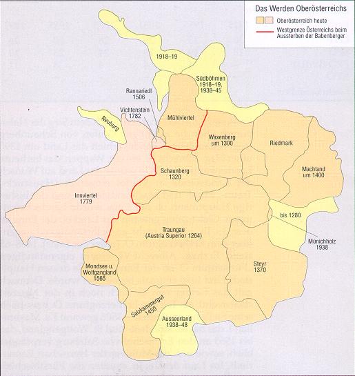
© Copyright Upper Austria: historic development Literature: H. Commenda, Materialien zur landeskundlichen Bibliographie Oberösterreichs, 1891; M. Vancsa, Geschichte Niederösterreichs und Oberösterreichs, 2 vols., 1905/1927; E. Straßmayr, A. Marks and J. Wunschheim, Bibliographie zur oberösterreichischen Geschichte, 1929ff.; F. Krackowizer and F. Berger, Biographisches Lexikon des Landes Öberösterreich ob der Enns, 1931; K. Eder, Studien zur Reformationsgeschichte Oberösterreichs, 2 vols., 1932/1936; K. Schiffmann, Historisches Ortsnamen-Lexikon des Landes Oberösterreich, 3 vols., 1935-1942 (ed. by P. Wiesinger et al., 1989ff.); OÖ. Heimatblätter, 1947ff.; E. Burgstaller, Lebendiges Jahresbrauchtum in Oberösterreich, 1948; Mttlg. des Oberösterreichischen Heimatarchivs, 1950ff.; E. Straßmayr, Bibliographie zur obersterreichischen Geschichte (ed. by Oberösterreichisches Landesarchiv), 1935-1948, 1950; ibid., Bibliographie zur oberösterreichischen Geschichte, 1949-1953, 1957; O. Wessely, Musik in Oberösterreich, 1951; A. Hoffmann and E. M. Meixner, Wirtschaftsgeschichte des Landes Oberösterreich, 2 vols., 1952; M. Khil, Biograph. Lexikon von Oberösterreich, 1955ff.; Atlas von Oberösterreich, 1958-1971; H. E. Baumert, Die Wappen der Städte und Märkte Oberösterreichs, 1958; F. Aschauer, Oö. Eisenbahnen, 1964; A. Marks, Oberösterreich in alten Ansichten, 1966; A. Hoffmann (ed.), Die Städte Oberösterreichs (Österreichisches Städtebuch, vol. I), 1968; Österreichische Akademie der Wississenschaften (ed.), Theatergeschichte Österreichs, Oberösterreich, vol. I, 2 nos., 1964, 1968; J. Reitinger, Ur- und Frühgeschichte Oberösterreichs, 2 vols., 1968-1969; Bauernland Oberösterreich, Entwicklungsgeschichte seiner Land- und Forstwirtschaft, ed. Landwirtsch.-Kammer für Obberösterreich., 1974; G. Winkler, Die Römer in Oberösterreich, 1975; H. Slapnicka et al., Beiträge zur Zeitgeschichte Oberösterreichs, 1975ff.; F. Achleitner, Ö. Architektur im 20. Jahrhundert, part 1: Oberösterreich, Salzburg, Tirol, Vorarlberg, 1980; Oberösterreich in Zahlen, 1981; R. Kropf, OÖ. Industrie, 1981; Oberösterreicher, Lebensbilder zur Geschichte Oberösterreichs, 1981ff.; L. Temmel, Evangelisch in Oberösterreich, 1982; Das neue Bild von OÖ. Forschungen zur Landeskunde von Oberösterreich 1930-80 (Festschrift 150 Jahre OÖ. Musealverein), 3 vols., 1983; H. E. Baumert and G. Grüll, Burgen und Schlösser in Oberösterreich, 3 vols., part 1: Mühlviertel und Linz, 1988, part 2: Innviertel und Alpenvorland, 1985, part 3: Salzkammergut und Alpenland, 1983; K. Pömer, Kunst in Oberösterreich, 3 vols., 1983-1985; F. Lipp, Oberösterreichische Bauernmöbel, 1986; S. Haider, Geschichte Oberösterreichs, 1987; W. Pesendorfer, Der Oberösterreichische Landtag, 1989; R. Lehr, Landeschronik OÖ., 21992; R. Zinnhobler, Kirche in Oberösterreich, 1992ff.; Ö. Raumordnungskonzept 1991 (ÖROK-series of papers No. 96), 1992; OÖ. Wirtschaftschronik, 1994; Öberösterreichisches Bundesdenkmalamt (ed.), Ö. Kunsttopographie: vol. 42 (Linz), 1977, vol. 43 (Kremsmünster), 1977, vol. 48 (St. Florian), 1988, vol. 50 (Linz), 1986. - Exhibition catalogues: Oö. Avantgarde, 1975; Der oberösterreichische Bauernkrieg 1626, 1976; Historische Dokumentation zur Eingliederung des Innviertels im Jahr 1779, 1979; 1000 Jahre Oberösterreich, Das Werden eines Landes, 2 vols., 1983; Kirche in Oberösterreich, 1985; Volksfrömmigkeit in Oberösterreich, 1985; Oberösterreich, Grenzland des Römischen Reiches, 1986. - Journals: Oberösterreichische Heimatblätter, Jahrbuch des Oberösterreichischen Musealvereins, 1833ff.; Mttlg. des Oberösterreichischen Landesarchivs, 1950ff. - Collection of source materials: Oberösterreichisches Urkundenbuch, 11 vols., 1852ff.
References to other albums:
| ||||||||||||||||||||||||||||||||||||||||||||||||||||||||||||||||||||||||||||||||||||||||||||||||||||||||||||||||||||||||||||||||||||||||||||||||||||||||||||||||||||||||||||||||||||||||||||||||||||||||||||||||||||||||||||||||||||||||||||||||||||||||||||||||||||||||||||||||||||||||||||||||||||||||||||||||||||||||||||||||||||||||||||||||||||||||||||||||||||||||||||||||||||||||||||||||||||||||||||||||||||||||||||||||||||||||||||||||||||||||||||||||||||||||||||||||||||||||||||||||||||||||||||||||||||||||||||||||||||||||||||||||||||||||||||||||||||||||||||||||||||||

