Information: This is an old - not maintained - article of the AEIOU. In the Austria-Forum you find an updated version of this article in the new AEIOU.
Zillertaler Alpen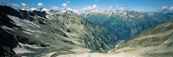
© Copyright Zillertal Alps. Zillertal Alps, Tyrol, strongly glaciated mountain range of the Central Alps between Birnlücke Pass (2,665 m) and Brenner Pass (1,370 m), consisting mainly of granite gneiss (central gneiss of the Ziller Valley core) and rocks from the slate cover of the Tauern mountain range (Tauern Window); divided by the Ziller Valley - Zemm Valley - Zamser Grund Area - Pfitscher Joch Pass (2,246 m) furrow into the northern Tux ridge (with the peaks Olperer, 3,476 m, Schrammacher, 3,410 m, and Hoher Riffler, 3,231 m) and the southern Ziller ridge (with Hochfeiler peak, 3,509 m), which forms the Austrian - Italian border. In the east the Zillertal Alps adjoin the Hohe Tauern Range; in the north they are separated from the Kitzbühel Alps by the Gerlos Valley - Gerlos Pass - Salzach Valley depression. South of Mayrhofen the "Gründe" (Ziller Valley, Zemm Valley, Tux Valley) give access to the Zillertal Alps. The Zillertal Alps are a popular skiing area (Hintertux, Mayrhofen, Gerlos Valley) with the ropeways Gerlossteinbahn (Hainzenberg - Gerlossteinalm) and Ahornbahn (Mayrhofen - Filzenalm). Moreover, almost the whole surface of the Tux glacier is used for summer skiing and made accessible by the Zillertaler glacier ropeways. Valsertal Valley nature preserve. Zemm-Ziller power stations of the Tauernkraftwerke AG. Mountain refuges: Berliner Hütte (2,042 m), Furtschaglhaus (2,293 m), Greizer Hütte (2,227 m), Kasseler Hütte (2,178 m), Tuxer-Ferner-Haus (2,605 m), Spannagelhaus (2,531 m), Friesenberghaus (2,477 m), Olpererhütte (2,388 m), etc. References to other albums:
| |||||||||||||||||||||||||||||||||||||


