Information: This is an old - not maintained - article of the AEIOU. In the Austria-Forum you find an updated version of this article in the new AEIOU.
Karnische Alpen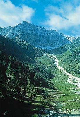
© Copyright Carnic Alps: Obertilliach Valley with Porze. Carnic Alps, in Carinthia and Eastern Tirol, eastern mountain range of the Limestone Alps, mostly formed from non metamorphic rock of the Palaeozoic, crest forming the frontier with Italy with a length of about 110 km and a width of 15 km, to the south of the Gail Valley reaching from the Puster Valley to Val Canale (Kanaltal); north-south watershed between the Black Sea and the Adriatic Sea. Highest elevation: Hohe Warte Mountain (2,780 m); the bordering mountains Reiterkarspitz (2,422 m), Porze (2,599 m), Roßkarspitze (2,511 m) and Helm (2,438 m) are part of East Tirol. The area around Lake Wolayer See (nature preserve) with the Wolayer Kopf Mountain (2,472 m) and Wolay pass (1,974 m, footpath only), the Kellerwand mountain with the Kellerspitzen (2,774 m) and the Cellon Mountain(2,245 m, Frischenkofel Mountain) are in Carinthia. Passes: Plöckenpaß (1,375 m), Hochalpe Naßfeld (1,530 m). Mountain refuges: Viktor-Hinterberger-Hütte (Sillianer Hütte) on Lake Füllhornsee near Sillian, Obstanser-See-Hütte (2,304 m) on Lake Obstanser See, Hochweißsteinhaus (1,867 m), Eduard-Pichl-Hütte (1,967 m), Dr.-Steinwender-Hütte (1,738 m). A special geological trail which can be followed all over the Carnic Alps was established in 1988 (geological open-air museum). Literature: H. P. Schönlaub, 500 Millionen Jahre Erdgeschichte in der Karnischen Region, 1988.
| |||||||||||||||||||||||||||||||||||


