Information: This is an old - not maintained - article of the AEIOU. In the Austria-Forum you find an updated version of this article in the new AEIOU.
Großglockner-Hochalpenstraße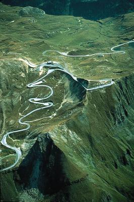
© Copyright Großglockner-Hochalpenstraße Großglockner-Hochalpenstraße (Glocknerstraße), high alpine road in the immediate vicinity of the Großglockner mountain, built 1930-1935 according to plans by F. Wallack; divided into 3 sections: 1) road through the Großglockner National Park (Nationalparkstraße) from Bruck in the Salzach Valley (province of Salzburg) through the Fusch Valley (Fusch, Ferleiten), over the Fuscher Törl (alt. 2,404 m) and the Hochtor (alt. 2,504 m, with 311-m tunnel) passes to the Guttal valley and Heiligenblut in the Mölltal valley, Carinthia (47.8 km long), and the branch roads: 2) from the Fuscher Törl pass to the Edelweißspitze peak (alt. 2,572 m; 1.6 km long) and 3) glacier road from the Guttal valley to the Franz-Josefs-Höhe (alt. 2,362 m, 8 km long). The Großglockner-Hochalpenstraße is a toll-road and is generally accessible from May to November. Average gradient 9 %, maximum gradient 12 %. Over 1.2 million visitors per year. Hochmais natural-science information centre (Edelweißspitze peak, "Roman Arch"), Alpine nature observation point, W.-Haslacher House. 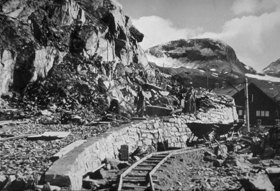
© Copyright Großglockner-Hochalpenstraße in construction, 1934. Literature: G. Rigele, Die Großglockner-Hochalpenstraße, 1998. References to other albums:
| |||||||||||||||||||||||||||||||||||||


